Featured Agency
Cedar Park, located about 20 miles north of Austin and home to roughly 50,000 residents, is one of the fastest growing suburbs in the Austin area. The City currently manages 50 signalized intersections, with all of the intersections currently using Iteris’ Vantage® video

Cedar Park, located about 20 miles north of Austin
detection systems. The City also recently utilized the design and engineering efforts of Iteris to create a new, world-class, Traffic Management Center (TMC). This includes a new PLANAR 3×2 55” LCD video wall and an overhaul of their network communication services, all of which will ensure that Cedar Park will be able to keep up with the rising traffic demand for years to come.
Problem
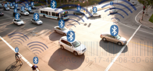
Along with the effort of improving the TMC, the City started to look at technology that could assist in evaluating travel time along principal arterial corridors. The City investigated several different technologies to perform this function, such as
magnetometers, loops, and radar systems, and decided that utilizing Bluetooth data and associated field equipment would be the most cost effective tool to collect this important Measure of Effectiveness (MOE).
Solution
After some detailed research of available products on the market, the City decided to invest in the Iteris Vantage Velocity™ Travel Time system in early 2013. The initial deployment of three field units along a three mile stretch of Lakeline Boulevard provides the City with an excellent baseline of travel time data to measure the effectiveness of its traffic signal coordination timing efforts.
Results
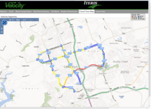
As the City started to analyze the data along Lakeline Boulevard, it quickly realized the Velocity Travel Time System was providing it with the data sets that it needed to assist with signal timing and
coordination. The output of the system with
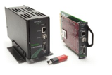
Vantage Velocity processors
an upgraded congestion map and real-time data was key in delivering the analytics and results the City came to expect from Iteris. The City then deployed an additional three field units along a second corridor in mid-2013 and another ten field units in September, 2013. Based on the value it sees in the system, the City now has plans for full coverage deployments that will be able to assist with further data collection analysis of not only real-time travel conditions, but also origin-destination studies and analyses.
[Download not found]